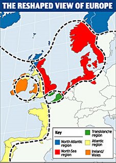
Some cartographic innovation from the EU
 Just seen this in Daily Mail, which is trailing it as part of a euro plot to break down national boundaries etc. I don't doubt that eurocrats have all sorts of nasty little schemes in the pipeline, but this appears to be fairly harmless and designed to foster cross border trade and so forth. Lots more maps here. The Transmanche thing which has got the Mail so steamed up is a lower tier region, and cannot legitimately be compared to the Baltic and Atlantic regions it also shows.
 Just seen this in Daily Mail, which is trailing it as part of a euro plot to break down national boundaries etc. I don't doubt that eurocrats have all sorts of nasty little schemes in the pipeline, but this appears to be fairly harmless and designed to foster cross border trade and so forth. Lots more maps here. The Transmanche thing which has got the Mail so steamed up is a lower tier region, and cannot legitimately be compared to the Baltic and Atlantic regions it also shows.
To be fair I'd rather be in with a region with Amsterdam, Copenhagen and Oslo than Glasgow, Blackpool or Llandudno
» Post a Comment